Analyses the triangles of the input TIN, finds the nodes that represent sinks (pits) or peaks. A TIN node participates in several triangles, each triangle is created from 3 nodes.
| If a node has maximum value in all triangles in which it participates it represents a Peak. | If a node has minimum value in all triangles in which it participates it represents a Sink or Pit. |
|
|
|
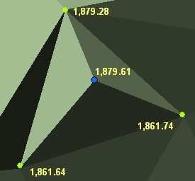
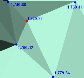
While the peaks in most of the cases represent natural features, the sinks with some exceptions (natural lakes and depression) are caused by incorrect data or interpolation.
Inputs:
- An ESRI TIN or PolygonZ TIN
- Output feature class
- Option to include/exclude in the analysis the flat triangles. Since all nodes in a flat triangle have the same Z value, if included in the analysis they in most of the cases will be either peaks or sinks.
Outputs:
- New Point or PointZ feature class.
- A new field is added to the point attribute
table.
- ET_Type - the type of the node - Peak or Sink
Command line syntax - two different toolbox tools available depending on the type of the input TIN. Check the color coding for specifics.
| ETS_GPPeaksAndSinksEsriTIN <Input TIN> <Out Feature Class> {3D Features} {Ignore Flat Triangles} |
| ETS_GPPeaksAndSinksPolygonZTIN <Input TIN> <Out Feature Class> {3D Features} {Ignore Flat Triangles} |
Parameters
| Expression | Explanation |
|---|---|
| <Input TIN> | An ESRI TIN layer or dataset |
| <Input TIN> | A PolygonZ TIN (feature class) |
| <Out Feature Class> | A String - the full name of the output feature class. |
| {3D Features} | A Boolean indicating whether the result will be PointZ or Point |
| {Ignore Flat Triangles} | A Boolean indicating whether the flat triangles to be included in the analysis. |
Scripting syntax
ETS_GPPeaksAndSinksEsriTIN (Input TIN, Out Feature Class, 3D Features, Ignore Flat Triangles)
ETS_GPPeaksAndSinksPolygonZTIN (Input TIN, Out Feature Class, 3D Features Ignore Flat Triangles)
See the explanations above:
<> - required parameter
{} - optional parameter
All ESRI
products mentioned are trademarks of Environmental Systems Research
Institute, Inc.
Copyright: Ianko Tchoukanski