Inputs:
- A polyline feature layer representing contours. It is strongly recommended to clean all possible gaps in the contours before using the Contour To Raster function. If your contour dataset has gaps use the Clean Contour Gaps function.
- Output raster name and format
- Cell Size of the output raster
- Elevation field - a field from the attribute table to be used as a source for the values of the raster. The Z values of the input PolylineZ dataset can be also used as source for the raster values.
Output:
- A floating point raster.
Example:
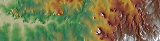 |
Notes:
- Initially the name of the output raster
defines the raster format
- no extension specified - ESRI binary GRID
- .img extension (for example raster1.img) - ERDAS IMAGINE image.
- .tif extension (for example raster1.tif - Tagged Image File Format (TIFF) image.
- The initial output raster format can be changed by selecting the desired output in the dialog.
- Currently only file based rasters are supported. Rasters cannot be stored in a GeoDatabase. After you get the desired result, you can export the raster to a GeoDatabase using the standard ArcGIS tools.
- The feature class must be in a projected coordinate system.
- The algorithm is specifically designed to use contours as input. If a polyline dataset that represents a different feature is used the results might be incorrect.
Command line syntax
ETS_GPContourToRaster <Input Dataset> <Out Raster> <Elevation Field> < Cell Size>
Parameters
| Expression | Explanation |
|---|---|
| <Input Dataset> | A Polyline layer or feature class |
| <Out Raster> | A String - the full name of the output raster (A raster with the same full name should not exist). The output raster type depends on the extension of the output file(see Notes above) |
| <Elevation Field> | A String representing the name of the field which values are going to be used for interpolation. |
| <Cell Size> | A Double representing the cell size of the output raster. |
Scripting syntax
ETS_GPContourToRaster (Input Dataset, Out Raster, Elevation Field, Cell Size)
See the explanations above:
<> - required parameter
{} - optional parameter
All ESRI
products mentioned are trademarks of Environmental Systems Research
Institute, Inc.
Copyright© Ianko Tchoukanski