Because the values of the curvature are typically small, the results of the curvature functions of ET Surface are the actual curvature multiplied by 100. So the value of the curvature can be described as the change of the orientation resulting from travelling one hundred linear units along the respective line.
The sign of the curvature is assigned differently by different authors. To keep consistency with ArcGIS the functions of ET Surface assign the sign as the corresponding functions of ArcGIS. If you want to change the sign you can use the Raster Calculator to multiply the result by -1.
The functions of ET Surface calculate the curvatures for each cell of a raster dataset using its immediate neighbors as devised by Zevenbergen and Thorne (1987).
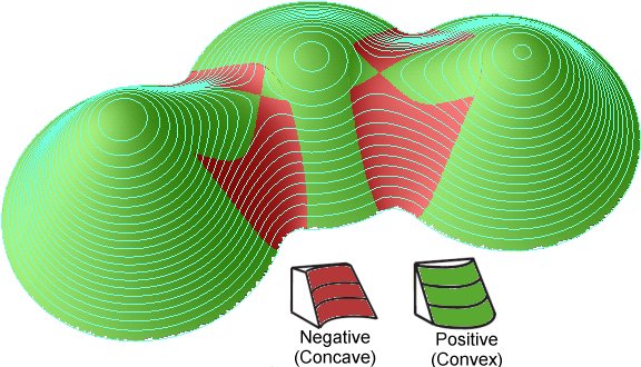
Plan Curvature is the curvature in a horizontal plane. It can be also described as the curvature of the hypothetical contour line that passes through a specific cell. The Plan Curvature is positive for cells with concave contours and negative for cells with convex contours. Plan curvature can be used to differentiate between ridges and valleys.
 |
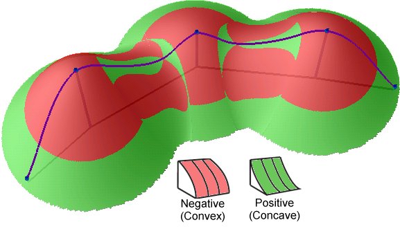
Profile Curvature is the curvature of the surface in the direction of the steepest slope (in the vertical plane of a flow line). The Profile Curvature affects the flow velocity of water draining the surface and influences erosion and deposition. In locations with convex(negative) Profile Curvature the erosion will prevail and in locations with concave (positive) curvature the deposition.
 |
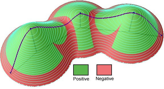
General Curvature (also called Total) is the curvature of the surface itself (not the curvature of a line formed by the intersection of the surface with a plane). The General Curvature can be positive or convex (indicating peaks), negative or concave (indicating valleys) or zero (indicating flat surface or a saddle).
|
Inputs:
- Input raster dataset
- Output raster name and format
Output:
- A floating point raster.
Example:
|
DEM (50% transparency) over hillshade |
 |
|
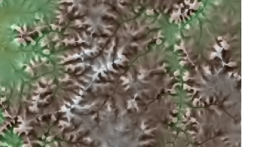
DEM (50% transparency) over Plan Curvature (20% transparency) over hillshade. Pronounced valleys and ridges. |
 |
Notes:
- Initially the name of the output raster
defines the raster format
- no extension specified - ESRI binary GRID
- .img extension (for example raster1.img) - ERDAS IMAGINE image.
- .tif extension (for example raster1.tif - Tagged Image File Format (TIFF) image.
- The initial output raster format can be changed by selecting the desired output in the dialog.
- Currently only file based rasters are supported. Rasters cannot be stored in a GeoDatabase. After you get the desired result, you can export the raster to a GeoDatabase using the standard ArcGIS tools.
- The input raster must be in a projected coordinate system.
Command line syntax
ETS_GPPlanCurvature <Input Raster> <Out Raster>
ETS_GPProfileCurvature <Input Raster> <Out Raster>
ETS_GPGeneralCurvature <Input Raster> <Out Raster>
Parameters
| Expression | Explanation |
|---|---|
| <Input Raster> | A Raster dataset or Raster layer |
| <Out Raster> | A String - the full name of the output raster (A raster with the same full name should not exist). The output raster type depends on the extension of the output file(see Notes above) |
Scripting syntax
ETS_GPPlanCurvature (Input Raster, Out_Raster)
ETS_GPProfileCurvature (Input Raster, Out_Raster)
ETS_GPGeneralCurvature (Input Raster, Out_Raster)
See the explanations above:
<> - required parameter
{} - optional parameter
References:
Zevenbergen, L.W. and Thorne, C.R. (1987) Quantitative analysis of land surface topography. Earth Surface Processes and Landforms.
Wilson, J.P., and Gallant, J.C. editors, 2000, Terrain Analysis: Principles and Applications (Chichester: Wiley).
All ESRI
products mentioned are trademarks of Environmental Systems Research
Institute, Inc.
Copyright: Ianko Tchoukanski