This function produces results similar to the results from the Weighted Voronoi Diagram function. The algorithm is different and non-integer weights can be used. Since the Weighted Voronoi Diagram is much faster, the better option is to use it instead of this function unless you need to have double values for the weights.
The performance of the function depends very much on the difference between the smallest and largest weights. The larger this difference is, the slower the function will be.
Inputs:
- A point feature class(Sources).
- The cell size of the output raster.
- Source ID field. The values from this field will be allocated to the cells of the output raster.
- Weight field. The values of this field will be used to define the weight of the sources. Any numeric field (integer or double) can be used as a weight field.
- Cutoff cost - cells with larger than this cost (distance x weight) to reach will not be allocated to any source.
Outputs:
- An integer raster. Each cell will have as a value the ID of the closest input point (Source). The extent of the output is equal to the extent of the input feature class.
Examples:
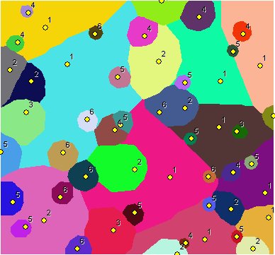 |
Points labeled with their weights. Integer weights used - the results very similar to the results produced by Weighted Voronoi Diagram . In this case the use of Weighted Voronoi Diagram function is recommended. |
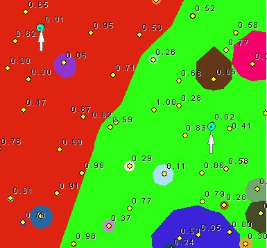 |
Points labeled with their weights. Double values for the weights used. The difference between the smallest weights (indicated on the image) and the largest ones close to 100 times. Expect long processing time. |
Notes:
- Initially the name of the output raster
defines the raster format
- no extension specified - ESRI binary GRID
- .img extension (for example raster1.img) - ERDAS IMAGINE image.
- .tif extension (for example raster1.tif - Tagged Image File Format (TIFF) image.
- The initial output raster format can be changed by selecting the desired output in the dialog.
- Currently only file based rasters are supported. Rasters cannot be stored in a GeoDatabase. After you get the desired result, you can export the raster to a GeoDatabase using the standard ArcGIS tools.
- The input feature class must be in a projected coordinate system.
- The result raster can be easily converted to a polygon feature class using the standard ArcGIS Raster To Polygon tool
- The attributes can be transferred to the polygons by joining the Raster Attribute Table to the polygons using GRID_CODE field of the feature class and the Value field of the raster attribute table.
Command line syntax
ETS_GPCostAllocationSource <Input Points> <Out Raster> < ID Field> <Weight Field> < Cell Size> {Cut Off Cost}
Parameters
| Expression | Explanation |
|---|---|
| <Input Points> | A Point layer feature class |
| <Out Raster> | A String - the full name of the output raster (A raster with the same full name should not exist). The output raster type depends on the extension of the output file(see Notes above) |
| < ID Field> | A String representing the name of the field in the input point feature class to be used as point ID. |
| <Weight Field> | A String representing the name of the field in the input point feature class that are going to be used as weights. |
| <Cell Size> | A Double representing the cell size of the output raster. |
| {Cut Off Cost} | A Double representing the cut off cost - the value of the cells with larger than this cost (distance x weight) to reach will be set to NODATA |
Scripting syntax
ETS_GPCostAllocationSource (Input Points, Out Raster, ID Field, Weight Field, Cell Size, Cut Off Cost)
See the explanations above:
<> - required parameter
{} - optional parameter
All ESRI
products mentioned are trademarks of Environmental Systems Research
Institute, Inc.
Copyright: Ianko Tchoukanski